Have you ever thought of hiking up an active volcano before? I never did – until my friend approached me to try – and I have not looked back since. Here’s my experience, as a virgin hiker, climbing the kick-ass mountain, known as Mount (Gunung) Merapi.
Also read: 5 Mountains in Indonesia with the Most Spectacular Views
The virgin
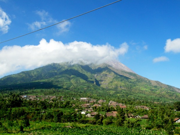
Gunung Merapi – standing at 2,930m – is one of the deadliest volcanoes in Indonesia, with the last major eruption in 2010 killing 38 people.
Hikes up Gunung Merapi typically begin in the wee hours of the morning, for both safety reasons (sulphuric gas emission in the day) and touristic reasons (reaching the summit in time for a phenomenal sunrise view). So at 2:00 AM, I wore my winter boots (the closest substitute to hiking boots), carried my backpack (stuffed with 1 litre of mineral water, 1 litre of energy drink, two packets of biscuits and a few chocolate bars) and started to climb Gunung Merapi with my friend, 2 fellow German travellers and 2 guides.
The first hour
“Huff… Puff… Huff… Puff…”
30 minutes into the hike I was already breathless and my back started to complain of a nagging ache. The start of the hike was merely on paved roads! Albeit – to give myself credit – they were on an incline. I blame it on the high altitude and thin air… okay, I was just unfit!
We finally reached the first pit stop in front of the “New Selo” sign and I was super thankful for a break. But even before I could inhale enough oxygen into my bloodstream, the guides have signalled us on – and oh no, that’s actually when the ‘real’ hike began.
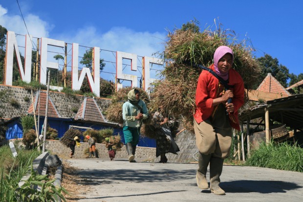 The paved, inclined roads leading to the first checkpoint
The ascent
The paved roads gave way to the actual jungle trail. The terrain continuously changed from dirt to rocks to tree roots, and from slopes to steps (carved by tree roots) to slopes again. But there was one constant: it was always on a 45-degree incline! My breathing got heavier, my back started to ache more and my pace slowed drastically. Soon after, we stopped for another short break.
The guide informed us that there will be 3 more rest points: namely plateau 1, 2 and 3 (how innovative) and I thought to myself, “What?! I am not even halfway up the mountain yet?!” My breath started to get more laboured and I had to stop every few steps for gulps of fresh air. However, I had to persevere! When my legs began to ache and lose its strength, I used my hands to give me that added push up the mountain.
I lost all sense of time and had no idea of how long I had climbed, but I just thought in terms of fragments – reaching the rest points at plateau 1.. 2.. 3.
“Hell, it’s freaking cold!” Even the rest points proved to be a constant battle between two evils: catching your breath or freezing in the cold (I wore 3 layers). But for me, the desperate need for oxygen always won over the biting cold anyway.
The (near) summit
“OMG. I can’t climb a single step more…”
And at this very moment, 3.5 hours into the strenuous hike, I finally caught sight of the summit. More crucially, the blood-orange rays from the waking sun were starting to permeate the darkness of the night sky! It was a sight to behold, and I knew I had to muster up every last drop of energy to reach the summit before daylight broke.
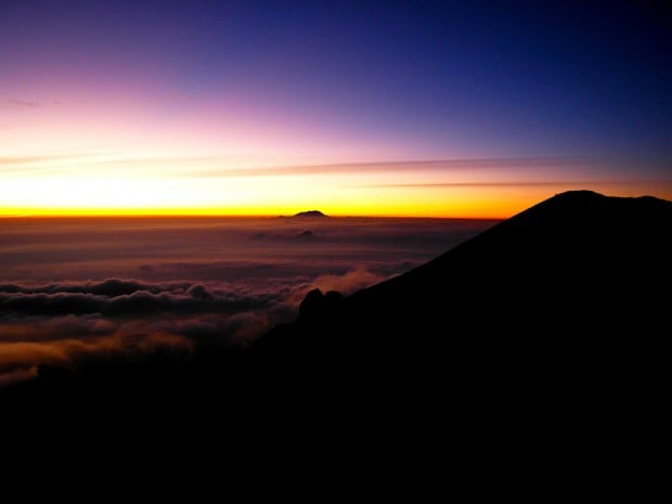
Views like this are sufficient motivation to reach the summit fast!
“I have to reach it before sunrise!” kept running through my head.
Energised by adrenaline flowing through my veins, I pushed forward with much vigour and took breaks only after longer intervals. Finally, I reached the (near) summit and lo and behold: these were the views that awaited me!
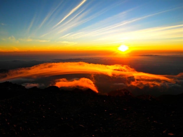
My favourite sunrise everrrrrrrrr!
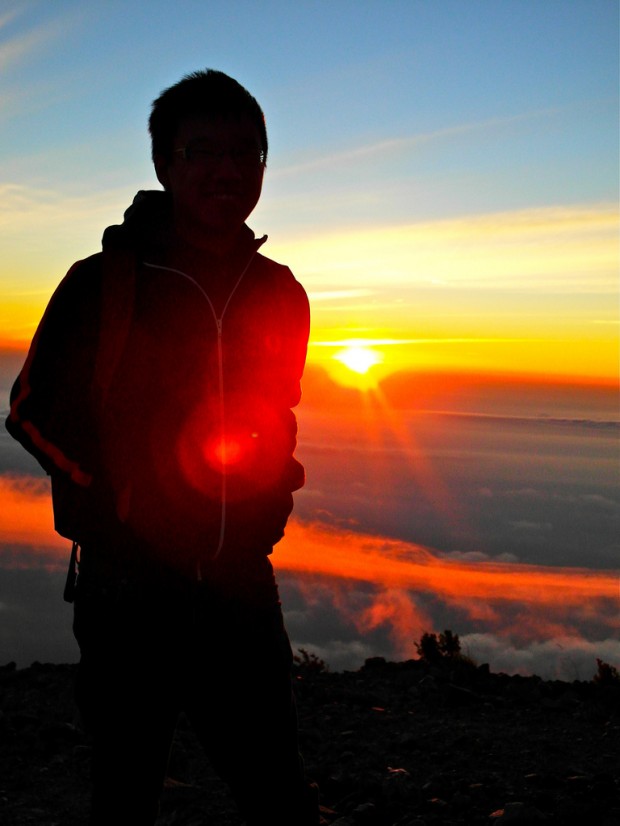
A silhouette shot is a MUST.
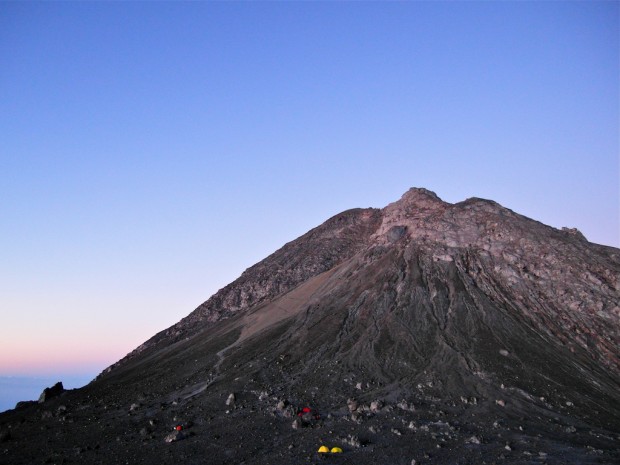
The reason why I said I had only reached the near summit: I couldn’t manage this final hurdle of climbing 200m of slippery rocks and ashes to the actual summit. If you are thinking of climbing it, you WILL need your hands!
Also read: 10 Mountains in Southeast Asia with the Most Incredible Views
The descent
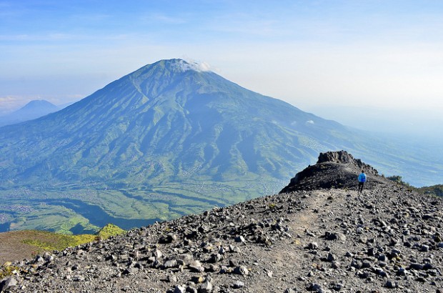 Image credit: Sergi Hill
The best might be over, but you still get gorgeous views on the way down!
After being enthralled by the views, feeling proud of achieving an almost impossible (to me) feat and snapping plenty of photos, it was time to go down the mountain. “The hard part is over, going downhill will be chicken feet!” Oh boy, how wrong was I! Going downhill at a constant 45 degree decline meant I had to rely on the muscles on my legs to stop gravity from throwing myself down the mountain! It certainly did not help that my muscles were already sore from climbing up. The end result? I tackled the slopes by sliding downhill on my butt! Not the most glamourous and cleanest method, but hey, it accomplished the task at hand.
The aftermath
After three hours of descent, my dust-stained jeans and I finally reached the rest stop at the “New Selo” sign again! “There’s 100-Plus sold here!” Despite the 2 litres of liquid I brought for the hike, I was still completely parched. I probably downed 2 whole cans of 100-Plus in record-breaking speed!
“That was an experience!” Sore arms, thighs, calves, glutes and groin continued to plague me for the few days after, but pain is temporary, memories are forever! This virgin hike taught me that the best views are always obtained after a bout of hard work, and there is immense pleasure to be gained from pushing through the pain barrier.
Useful information
Thinking of hiking Mount Merapi now? Here are some useful information to get you started:
- How to get there: Mount Merapi is located closest to the city of Jogjakarta, also famous for its proximity to the historic Borobudur and Prambanan temples. From Jogjakarta, you can book tours for the hike with most accommodations and travel agents for about IDR 300,000 (~USD 22) per person, minimum of 2 persons.
- Things to bring: Plenty of water (at least 2 litres), snacks/energy bars, warm jackets (temperature likely to hit single digit on the mountain), proper shoes and torches.
- Duration of hike: The hike takes about 6 to 8 hours, depending on your fitness level.
- Fitness level: Not the toughest mountain out there, but a moderate fitness level is still required to tackle the constant incline of the hike.