Driving from Singapore to Genting Highlands is a popular choice for holiday-makers, but many find themselves dreading one part of the journey: navigating the congested roads around Kuala Lumpur (KL). Tight exits, heavy traffic, and confusing junctions often create unnecessary stress before the climb up the mountain even begins.
Fortunately, there is a smoother, calmer alternative. A route that bypasses the worst of KL traffic and connects drivers directly to the Karak Highway with ease.
Also read: 14 Things to Do in Genting Highlands, Including New Attractions!
Starting from Singapore: Tuas Checkpoint to the North–South Expressway (NSE)

Image credit: ellinnur Bakarudin via Canva Pro
Most drivers heading to Genting begin the journey via Tuas Checkpoint, which connects directly to Malaysia’s well-maintained highway system. The route is simple and efficient:
-
Clear Tuas Second Link
After immigration, continue straight on the Second Link Expressway (E29). -
Merge onto the North–South Expressway (NSE / E2).
Follow signs towards Johor Bahru / Kuala Lumpur. The expressway begins shortly after the toll plaza. -
Continue north on the E2.
This long stretch takes you past major cities such as Melaka and Seremban. It is a smooth, straightforward highway with regular rest stops, ideal for fuelling up, toilet breaks, and refreshments. -
Approach Greater Kuala Lumpur.
As you near KL, remain on the E2 unless signage indicates otherwise. Avoid entering city roads; the aim is to stay on highways that skirt the city.
From here, the key is to connect to the easier elevated route — the E19 — which bypasses KL’s busiest areas entirely.
The usual challenge: KL’s congested core
Most navigation apps automatically route vehicles through central Kuala Lumpur, where multiple highway splits, dense traffic, and sudden exits can make the drive stressful. This is often the stage where drivers face the most fatigue and confusion.
The better alternative: E19 elevated highway
The E19 elevated highway offers a noticeably more relaxed driving experience. This three-lane expressway rises above the city, avoiding ground-level congestion and guiding drivers smoothly towards the Karak Highway.
Key advantages include: Lighter traffic compared with central KL routes, wide, stable lanes suitable for long-distance driving, clear directional signage and direct connection to the Karak Highway.
Because this is a multi-level road system, GPS signals may occasionally falter. In such cases, it is recommended to rely on highway signs rather than app instructions.
Driving up to Genting Highlands: Follow Kuantan via E19
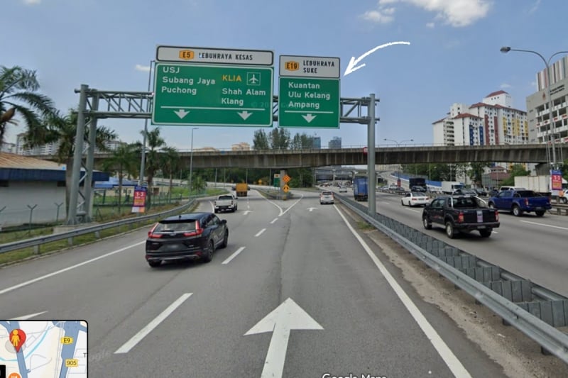
Image credit: Google Maps
When approaching Kuala Lumpur from the south on the E2, look out for the exit directing you to Kuantan via the E19. This is the crucial turn-off that leads onto the elevated expressway.
Once on the E19, continue following Kuantan signs until you reach the entrance of the Karak Highway (E8), which takes you directly towards Genting Highlands.
Driving down from Genting: Follow Seremban via E39
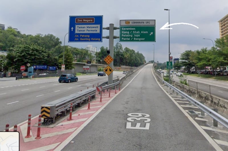
Image credit: Google Maps
For the return journey, look for the E39 / Seremban exit near KL East Mall, keep right and go up the ramp. This brings you onto the same relaxed elevated system, now guiding you southwards. Continue following Seremban signs to rejoin the North–South Expressway (E2), which leads back to Johor and ultimately to the Tuas Checkpoint.
Why choose this route
The combination of the E19 and E39 highways offers a number of advantages that make the journey to Genting Highlands considerably more pleasant. These highways enable drivers to bypass the busiest areas in central Kuala Lumpur, resulting in a smoother and less demanding overall drive. With clearer lane splits and predictable signage, navigation becomes more straightforward, helping reduce stress well before the winding ascent to Genting begins.
Also read: 10 Must-Try Restaurants in Genting Highlands
Additional tips for a safer and smoother drive
For an even more comfortable trip, refuel early, ideally before approaching Kuala Lumpur or beginning the climb up Genting. It is wise to check weather forecasts too, as fog or rain is common in the highlands. Ensure your Touch ’n Go card has sufficient balance for tolls, including those along the Karak Highway. Drive cautiously on the ascent, as vehicle speeds can vary widely, and rely on physical road signs on elevated highways where GPS instructions may be less reliable.